
Our route back off the Flerieu Penisula and down the coast led to this ferry crossing of the Murray River. The Murray is one of Australia’s major rivers, with over 2,000 miles of navigable water. It was a historic waterway before the land was cleared for roads, rather like the Mississippi .

Another famous giant Australian roadside attractions. This huge lobster was actually for sale!
Wouldn’t this look good in your yard?
 At the end of that short day of driving, we made it to Mt. Gambier, and had a pizza. While eating, we heard about the nearby Blue Lake park, and went to investigate. It turned out to be a great spot in the middle of the town, with a street and bike paths around the rim of a deep crater. It is the remnant of a volcanic explosion, but is not actually a volcanic lava cone. Instead, it’s a cone formed when groundwater in the limestone below turned to steam and blasted through a flat lava cap, blowing the limestone and cap out. It’s now the city reservoir. We hoped to find a quiet spot to park for the night, but it was all posted, so we moved on down the road a piece.
Another famous giant Australian roadside attractions. This huge lobster was actually for sale!
Wouldn’t this look good in your yard?
At the end of that short day of driving, we made it to Mt. Gambier, and had a pizza. While eating, we heard about the nearby Blue Lake park, and went to investigate. It turned out to be a great spot in the middle of the town, with a street and bike paths around the rim of a deep crater. It is the remnant of a volcanic explosion, but is not actually a volcanic lava cone. Instead, it’s a cone formed when groundwater in the limestone below turned to steam and blasted through a flat lava cap, blowing the limestone and cap out. It’s now the city reservoir. We hoped to find a quiet spot to park for the night, but it was all posted, so we moved on down the road a piece. 
The next morning we were out on the coast, checking out some of the grand sights on the Great Ocean Road. This is the London Bridge, with an arched island remaining intact from an eroded headland. The ocean waves and currents were very impressive.
 It’s interesting that here in the state of Victoria the highways are marked with reminders for the driving tourists. We have been in three other states (New South Wales, Queensland, and South Australia) for over three weeks of driving, and these were the first directions we saw regarding which side of the road to use. Obviously, visitors pull out of the scenic viewpoints and head on down the road in a dangerous manner….
  There are numerous spots where the rock cliffs have eroded and re-precipitated into fantastic shapes. The cliffs seem to me to be sandstone, but then they act like this, in the manner of limestone deposits. There are both types in the area, and this may be a combination.
What does it look like to you, Matt?

This was the Loch Ard Gorge. It was one of the few spots folks could get down to the beach along one section and was quite popular. This is where the stalactite-type formations were. It is apparently a more eroded example of a huge collapsed sea cave, the natural way this coast is taken apart by the elements.
 This Blowhole was “breathing” noisily, but perhaps is quite the sight when the seas are higher and wilder than the day we stopped by. It actually includes another section of long cave, directly below the spot I took this photo.
See the story about this hole on the next photo.
 They do not mention how the bodies were recovered. There is a graveyard very nearby.
The only two people to survive washed up inside the Loch Ard Gorge.
 A long piece of this highway runs along the cliffs, with crashing surf washing over beaches and rocks below. It is a great piece of road if you like driving a motorcycle, and was quite popular the day we came through.
 It seemed very much like the coast highway in Oregon and northern California.
 We were there the day before the Melbourne Cup, which is a very popular horse race. The entire country almost shuts down for race day, and many folks apparently extended their weekend to take advantage.
  We stopped by a tiny pullout opposite the ocean and took a short break hike up a little 4X4 road labeled the “Godfrey Track”. It was quite steep and eroded at the bottom, but wound up into the forests in a way we could not resist.
It would be great to know just how far one could wander up into the hills. The trees were gorgeous, there were butterflies and birds…..

But although we scanned the forest carefully, the koalas were not to be seen.

OK, if you are going to build a place with a view of the ocean and the cliffs, this is the way.
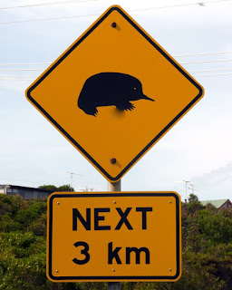
We were told that this is a warning to watch for echidnas, a hedgehog-type creature.
I thought it was the burrowing unicorn sea mole….

Hmmm . . . those redeposited features (aka "tufas") definitely indicate limestone . . . but I'm not sure what about it made you think sandstone. Guess I'll have to see more photos when you get back.
ReplyDelete